
 Yahoo Autos
 Daily storms and heat. When is Saharan dust coming to change Florida’s weather a bit?
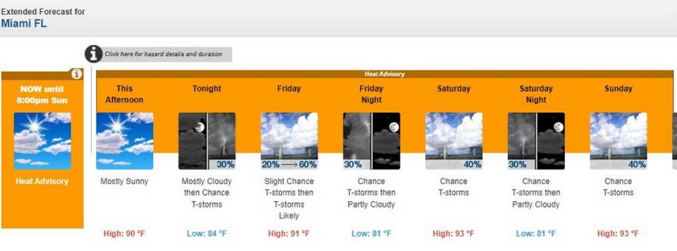
Update: On Thursday, the National Weather Service in Miami expanded its heat advisory to 8 p.m. Sunday. The heat index could range from 106-112.
There are more storms in Wednesday’s forecast for the Miami area and the Florida Keys, and a few of these could be “strong to marginally severe,” according to the National Weather Service in Miami.
The heat advisory has been extended through 8 p.m. Sunday in South Florida, surpassing a 40-day stretch of heat index readings of at least 100 degrees, according to Brian McNoldy, a senior research assistant at the University of Miami’s Rosenstiel School.
#Miami has broken 22 daily heat index records in the past 35 days. Contributing to those are 9 new record high temperatures and 8 new record high dewpoints. Warmer air can hold more moisture, and it certainly has been! https://t.co/7muPgS5u3s pic.twitter.com/dysIu5A3w6
— Brian McNoldy (@BMcNoldy) July 19, 2023
Given nearly a week of consistently impressive lightning storms one has to wonder, where’s the Saharan dust to dry us out a bit?
Be careful what you ask for, though. That dust also turns up the heat.
Let’s get to the forecast.
Local forecast
7/20: No end in sight to the #heat for South FL as the afternoon temps peak in the low-mid 90s and the heat indices reach 105F-110F.
Some relief in the form of scattered showers and storms will be possible this morning (East Coast) and later this afternoon (Gulf Coast). #FLwx pic.twitter.com/FLorniZXhv— NWS Miami (@NWSMiami) July 20, 2023
Scattered to numerous showers and thunderstorms started developing across parts of the Keys like Cudjoe Key, Marathon and Big Pine Wednesday morning and are expected to move across Miami-Dade and Broward by the afternoon, according to CBS News Miami meteorologist Lissette Gonzalez and the weather service. Rain had already moved into the Kendall area by 10 a.m.
A few of these storms could be bangers, with wind gusts topping 50 mph. The heavy rains could lead to localized flooding into the evening hours and a waterspout can’t be ruled out, the weather service said.
Storm chances in South Florida are 60% Wednesday, 50% Thursday, 50% to 60% Friday and 40% Saturday and Sunday.
Storm chances in the Keys are 70% Wednesday, 60% Thursday and 40% Friday. The weekend looks drier with temperatures in the mid-90s.
Saharan dust relief?
Tracking some storms moving across parts of the Keys and we'll see scattered storms moving in across parts of #SouthFlorida today @CBSMiami pic.twitter.com/fhrQwlVKzL
— Lissette Gonzalez (@LissetteCBS4) July 19, 2023
Another wave of Saharan dust is on the way “and it looks like it’ll start to really push in here late Thursday and should stick around into the weekend and possibly even into early next week,” said National Weather Service meteorologist Luke Culver.
7/19: A plume of Saharan Dust is forecast to approach South Florida this upcoming weekend. This will limit the overall coverage of showers and thunderstorms which will result in hotter temperatures with potential high temperatures in the middle to upper 90s across the area. pic.twitter.com/dlLDh1gzjs
— NWS Miami (@NWSMiami) July 19, 2023
KNOW MORE: How Saharan dust can affect storms, heat and your health
The coming dust plumes will likely lower chances for storms, despite the forecast still calling for a better than even chance of some thunderstorm activity into the weekend.
“There’s not going to be no rain but the typical afternoon convection will be hampered a bit by it,” Culver told the Miami Herald.
That’s not all that Saharan dust’s dry air mass does. It can hamper activity in the tropics but it also exacerbates our ongoing heatwave.
Hotter heat on the way?
READ MORE: Dogs and cats feel Florida’s daily heat records, too. Here’s how to keep your pets safe

As a result, look for warmer temperatures. Look for highs in the low 90s with a “feels-like” heat index of 109 Wednesday and Thursday. Once the dust does its thing in the upper atmosphere over South Florida “it will be warmer than what we’ve been seeing now,” Culver says. “Looks like the stretch of heat advisories is going to continue and we may even need to bump those up to excessive heat warnings potentially over the weekend.”
That means a heat index reading of 110 degrees or more.
Thursday’s projected heat index readings included 109 in Miami, 110 in Homestead, 107 in Fort Lauderdale and 113 in West Palm Beach, according to the weather service.
The weather service issued its first excessive heat warning for Miami-Dade County last Sunday, prompting the county to open up 14 cooling sites, the Herald reported. An excessive heat warning is triggered when relative humidity combined with the air temperature brings the index to 110 degrees or higher for at least two hours.
Tropical Storm Don gains strength as hurricane center watches wave. What the forecast says
