
 Yahoo Autos
 Severe weather expected in southern Wisconsin while multiple rounds of snow are likely up north
Severe weather is expected to affect the southern part of the state into the weekend as the Milwaukee area prepares for the possibility of thunderstorms.
Up north snow continues to make its way toward Green Bay and Appleton but is unlikely to make it to Milwaukee as temperatures continue to rise.
As a sporadic weather event continues to move into Wisconsin here is what to know.
Milwaukee area likely to see severe weather
Rain in the Milwaukee area is expected to start on Friday afternoon and continue into the early hours of Saturday. During the storm, the Milwaukee area will likely see between 0.75 inches to 1.25 inches of rain.
Snow is unlikely, but still possible in the early hours of Saturday, as temperatures are expected to start trending more mildly going into next week.
While Milwaukee is firmly in the path of the oncoming severe weather, experts at the National Weather Service say that the area is unlikely to bear the brunt of what the system is bringing, however, concern about severe weather has increased as the storm tracks closer to Milwaukee.
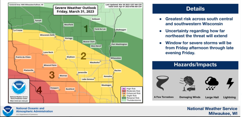
“It's still possible that some of these storms could move east and become severe even in Southeast Wisconsin. Again, the timing would probably be late — probably more late afternoon, evening for the Southeast Wisconsin Milwaukee area,” said national weather meteorologist JJ Wood.
As the system moves in on Friday scattered thunderstorms are expected to start around 2 p.m. — these storms will bring high winds and possibly large hail. The more severe effects of the system will be felt on Friday night, between 5 and 9 p.m., and are expected to bring thunderstorms, large hail and damaging winds.
