
 Yahoo Autos
 'The time is now': New Mexico taking action on oil and gas-induced earthquakes
A growing threat of earthquakes in southeast New Mexico prompted the State to take action by upping its seismic monitoring and calling for oil and gas operators to curb the amount of produced water disposed of underground.
The byproduct water, known as produced water in industry terms, is a combination of flowback water created during hydraulic fracturing operations and water brought up from underground shale formations along with oil and natural gas.
Traditionally this water, briny and contaminated with toxic chemicals, is pumped back into the shale for disposal, but such a process was recently linked to increased seismic events in the Permian Basin shared by southeast New Mexico and West Texas.
More: Eddy County oil and gas revenue collections rise in September
Earlier this year, the Texas Railroad Commission announced it was establishing two seismic response areas (SRAs) in the Midland area and along the Texas-New Mexico border in Culberson and Reeves counties. It called for reductions in produced water injection volumes and advocated blocking any new permits for saltwater disposal wells (SWDs).
And on Tuesday, New Mexico’s Oil Conservation Division (OCD) announced similar actions as a string of earthquakes were reported in New Mexico throughout November.
Permits under review for SWDs in the area south of Malaga, near the Texas State Line, will require additional review, the department said.
More: Oil and gas 'the future' of Carlsbad and New Mexico
Meanwhile, a “statewide response protocol” was put in place by the OCD that will increase reporting and monitoring measures while also reducing the volume of water injected based on further observed seismic activity.
“Category 1” of the protocol would go into effect when two quakes of magnitude (M) 2.5 or higher occur within 30 days and within a 10-mile radius of each other.
An M 2.5 earthquake is the first level where it could be lightly felt, according to the Richter Scale. Serious damage can occur at a M 3 or greater.
More: New Mexico environmentalists, industry debate impact of EPA oil and gas methane rule
With 10 miles of the epicenter of such an event, operators would be required to provide to the state weekly reporting of daily injection volumes and average daily surface pressure, while digitally measuring injections volumes and pressure and providing analysis and data to the OCD when requested.
At “Category 2,” which goes into effect if one M 3 event occurs, all of Category 1 requirements would be imposed, along with requirements that operators within 3 miles reduce injection rates by 50 percent.
Within 3-6 miles, operators would be required to cut injection by 25 percent.
More: New Mexico, Permian Basin oil and gas environmental concerns heard at UN's COP26 summit
If a M 3.5 or higher quake is reported, operators with 3 miles must shut in their wells, and cut injection by 50 percent at 3-6 miles, and 25 percent at 6-10 miles.
OCD Director Adrienne Sandoval said most of the recent significant seismicity was reported on the Texas side of the basin, but the State was taking action to prevent the threat to New Mexico.

“The Oil Conservation Division is taking a proactive approach to managing seismic activity tied to oil and gas activity in New Mexico,” she said. “While some of the biggest events have occurred over the state line in Texas, the time is now to ensure larger events do not occur in our part of the oil field.
“Using solid data and working with our stakeholders and state partners, the plan laid out today takes a pragmatic approach to addressing this issue.”
More: New Mexico's oil and gas water research studies economics, toxicity
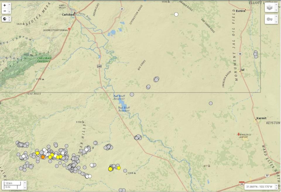
Data shows earthquakes increased while oil boomed in the Permian Basin
Data from the U.S. Geological Survey (USGS) showed that along the Texas-New Mexico border in the Permian Basin, 422 earthquakes of M 2.5 or higher were reported in 2021, with 22 reported in November alone.
