Yahoo Autos
10 Reasons Why Southwest Wisconsin is One of The Best Motorcycle Touring Destinations
There are great reasons to tour most any part of this good ol’ country of ours. Each locality has its own unique appeal, historic sites, man-made and natural points of interest, and events.
Of course, a lot of the touring stories tend to focus on the east coast and west coast destinations with their ocean views, or the mountains on each end of the country with their soaring skylines and rock formations, or the deserts with their spectacular sunsets and abundant sunshine. Sure, there are great rides in all those areas—but the emphasis on those areas leaves the other areas of the country less-covered and, as a result, less traveled.
The upper Midwest is a great example. There is a part of the upper Midwest in the Southwest corner of Wisconsin that is unlike anything else in the region. It is called the Driftless area and its unique place in history and unexpected geographical features make it an absolute must for your touring bucket list.
MUST READ: Top Ten Bikes at The Slimey Crud Motorcycle Gang Cafe Racer Run | RideApart
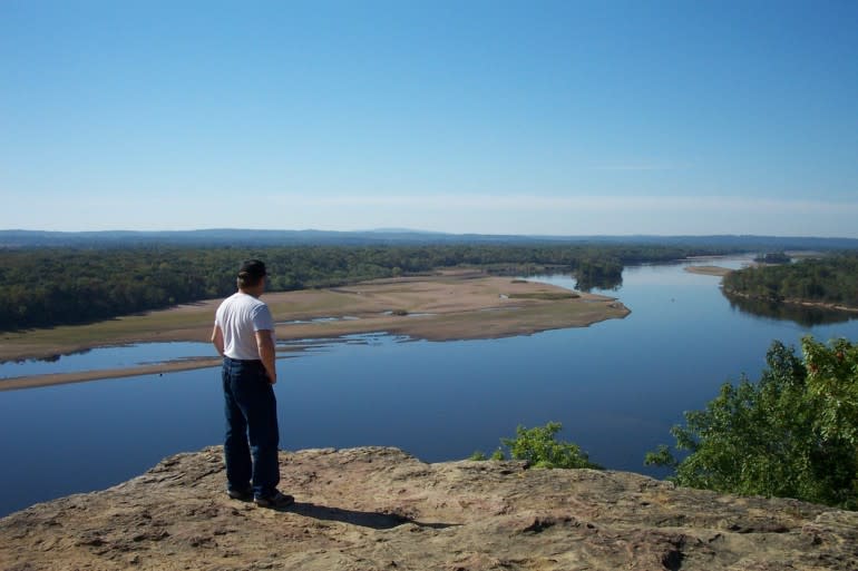
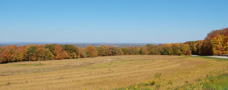
The view from atop Cactus Bluff includes the Wisconsin River and the Blue Mounds on the horizon in the distance.
You’re Bluffing!
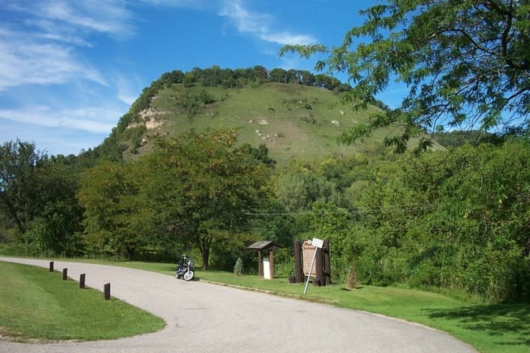
Ferry Bluff and Cactus Bluff—Sauk County. Sauk County has some of the best motorcycle touring roads in a part of Wisconsin that is literally laced with great touring routes. The one I have in mind here is a single-lane gravel road, but it is not a long road and it is worth the trip. Take state highway 60 (itself designated as a Scenic Byway) about six miles west of Sauk City and turn left on Ferry Bluff Road. Take it to the end and there’s a small—I mean you’ll be glad you’re on a motorcycle small—parking area next to a slough of the Wisconsin River. From there, take the foot path to the top of Cactus Bluff and you’ll be treated to a magnificent view of the Wisconsin and it stretches to the horizon to the south with the soaring Blue Mounds visible in the distance. At the top of the bluff, there is an interpretive display provided by the Wisconsin Department of Natural Resources (http://dnr.wi.gov/) that makes for a greater understanding of the area’s geology and natural history.
Tips for maximum enjoyment: wear good walking shoes, bring binoculars, camera/videocam if your phone isn’t equipped, take a bottle of drinking water or two along and take your time. The last few hundred feet of the walk are fairly steep.
The Kickapoo river can be a wild torrent in the spring, but in the summer, it is beautiful little river to follow for its entire length.
Kickass Kickapoo
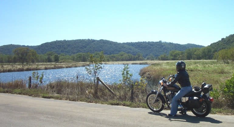
The Kickapoo River is not long, nor is it wide, except during the spring run-off, but it is scenic and the river meanders 65 miles through the rugged Ocooch Mountains from near the town of Summit in Monroe County to its confluence with the Wisconsin River at Wauzeka. Cruising its zig-zag valley on state highway 131from where it joins state highway 60 near Wauzeka heading north, you can traverse the entire length of the river from its mouth to headwaters. Stops on the way might include neat little villages like Steuben, Gays Mills, Soldiers Grove, Readstown, and Viola. Viola is the ancestral home of S&S Cycle. In spring, the Kickapoo River can become a kickass roaring torrent with snowmelt and rain run-off rushing down the steep, narrow valleys it drains.
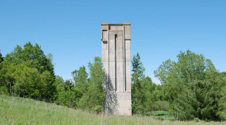
This bizarre obelisk is actually the concrete hulk of what was to have been the flood gate control tower of the huge dam that never was near Lafarge on the Kickapoo.
The problem was so extreme, that back in the sixties the federal government tried to step in—resulting in one of the most epic fails of government policy in U.S. history. The decision was made to evict hundreds of people from their homes upstream from LaFarge, WI, where the feds planned to build a massive dam across the valley to control the river. By 1975, the project—which had already spanned about three-quarters of the valley stalled on the realization that it was a disaster in the making and all that remains of the dam that never was is that unfinished portion of the dam and this bizarre concrete obelisk that was to have been the control tower for the flood gates. The land owners who lost their land were not allowed to get it back and the Kickapoo Valley Reserve was created instead.
If the panoramic view from Brigham Park is spectacular in summer it really lights up with the colors of fall.
Bring it on Brigham Park:
Not far from Wisconsin’s Blue Mounds State Park is Dane County’s Brigham Park. It is perched on the crest of what is known as the Military Ridge and boasts a panoramic view north across the broad Wisconsin River valley that only the birds would normally enjoy, but you can see it from the saddle of your bike or from one of a series of benches along county trunk F that winds its way to the summit from the north. It covers 112 acres and includes a group camp area, a 25 unit rustic campground, two shelter facilities, toilet facilities, picnic area, play equipment, and a self-guided nature trail through a maple woods.
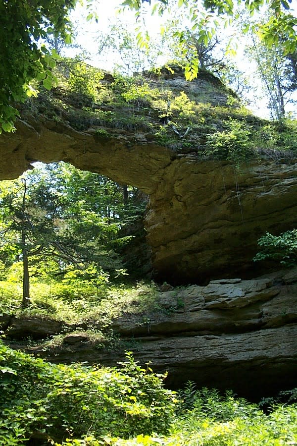
The natural bridge near Leland was carved by the outwash from melting glaciers thousands of years ago.
Natural Bridge State Park and Pier Park Rockbridge:
Many people who live in southwestern Wisconsin don’t know that there are two natural bridge rock formations similar to the famous ones in Utah right in their own back yard. One is located near Leland in Sauk county in Natural Bridge State Park; the other is in Richland county in Pier Park at Rockbridge. County trunk highways C and PF will take you to the Natural Bridge near Leland (which is also the end point of the Slimey Crud Motorcycle Gang Café Racer Run). At Natural Bridge State Park, the bridge is a classic soaring arch of sandstone 35 feet high and countless thousands of years old, with a cave carved below it, which is believed to be one of the oldest human habitation sites in North America. At Pier Park, the bridge takes the form more of a colossal sandstone wall with natural tunnel that runs through it east-west between the two parts of the park. The Pine River hugs the cliff on the west side and then cuts through it in a tunnel of its own. Rockbridge is on state highway 80 about ten miles north of Richland Center and the two sites are an easy and scenic ride apart. Get it—ride apart? Sorry—I had to do it.
MUST READ: First look: Avinton – from France with love and S&S power from Wisconsin! | RideApart