
 Yahoo Autos
 Arizona waterfalls will be thundering this spring. Here's where to see 8 of the best
March has been a rough month for waterfall lovers in Arizona.
First, the Navajo Nation announced that chocolate-colored Grand Falls would be closed indefinitely to visitors due to the mounds of trash left behind and off-road damage caused by careless tourists.
Then over St. Patrick’s Day weekend, visitors to iconic Havasupai Falls in Grand Canyon had to be rescued after a late winter flood, with many carried out by helicopter. The flooding came just weeks after the Havasupai Tribe had reopened access to the canyon known for its majestic blue-green waterfalls for the first time since March 2020.
Fortunately, Arizona boasts a surprising array of beautiful torrents, big and small. With heavy winter rains and abundant snowmelt, waterfalls will be flowing in the coming weeks. Here are some of the best in Arizona. Just remember to treat these special places with respect. Carry no glass containers and pack out all your trash. And doublecheck that roads to your destination are in fact open if there's been inclement weather.
Is it a superbloom?Here are the best places to see Arizona wildflowers in spring 2023
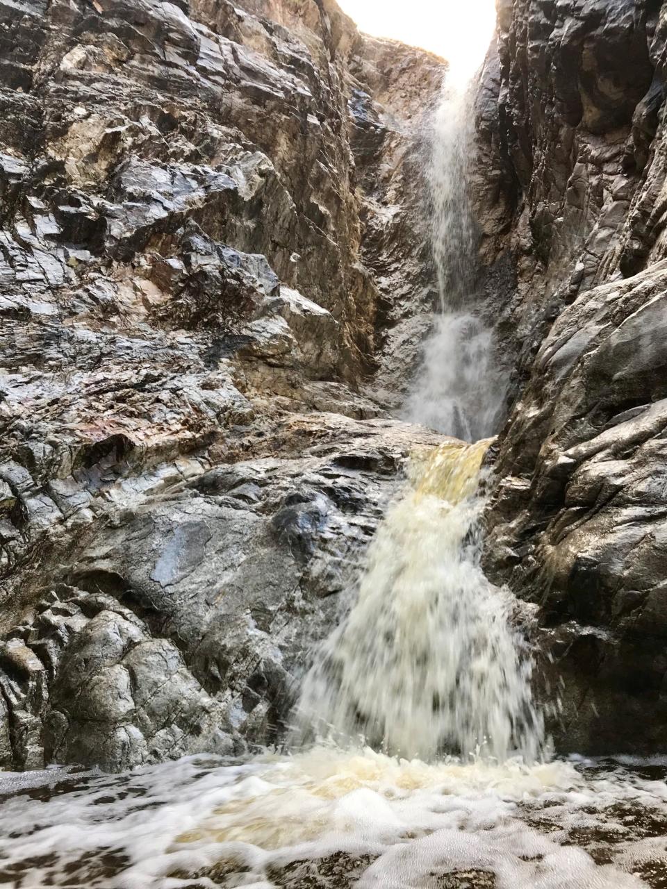
Tucson: Tanque Verde Falls
A creek cuts a narrow canyon through the Rincon Mountains and that makes for one of the most popular adventures in Tucson — an outing to two impressive waterfalls. The smaller is about 25 feet tall, while the other makes an 80-foot plunge into big pools.

Start with a steep half-mile descent into the canyon bottom. From there, pick a route through the streambed for another mile, rock hopping and scrambling over boulders. It’s a perilous trail and more than 30 people have died from drowning or falls. So this is not one to take lightly.
Even if you don’t make it all the way to the main waterfall, you’ll enjoy a series of smaller cascades, streams and pools along the way.
Details: Drive east on Tanque Verde Road until it becomes Redington Road. Soon after the pavement ends, look for the signed parking area on the left. Free. 520-749-8700, www.fs.usda.gov/coronado.
Best Tucson hikes:Where to see waterfalls, mountains and a rare crested saguaro cactus
Sedona: Angel Falls
The tall red mesas and buttes of Sedona seem designed with waterfalls in mind. Angel Falls is a 300-foot seasonal cascade that plunges from the high ramparts of Wilson Mountain.

Set out on the Brins Mesa Trail from Jordan Road. Level for the first mile, the trail climbs steeply to the mesa rim. Once at the top, an unmarked trail bears right to a red rock overlook, and then continues on through the chaparral for another half-mile or so for a view of the falls.
Details: From uptown Sedona, drive west on Jordan Road. Follow it about a mile to the trailhead. A Red Rock Pass ($5 per day) is required.
New in Sedona:Unexpected destinations, new hotel and spa options
Sierra Vista: Carr Canyon Waterfall
Following heavy rains, a frothy 200-foot waterfall pours down the exposed rock cliffs of Carr Reef in the Huachuca Mountains. You'll want a high-clearance vehicle and a careful driver.
The towering cascade is best viewed from narrow, winding Carr Canyon Road. After 1.4 miles the pavement ends as the road enters Coronado National Forest and begins a steep climb hugging the mountainside.
Narrowing to one lane amid a series of sharp switchbacks, the road has pullouts to keep traffic flowing. A pullout at about 4.5 miles provides an overlook of the falls. But stay well back from the wet boulders. Over the years, several people have fallen to their deaths here.
Carr Canyon Road continues for another 3 miles, passing two campgrounds and the ghost town of Reef before ending amid the ponderosa pines.
Details: From Sierra Vista, travel south on State Route 92 for 6 miles to Carr Canyon Road. Turn west and drive 7.5 miles up the mountain. Most of the road is unpaved and rocky. A high-clearance vehicle is required. Free. https://www.fs.usda.gov.
Road trip inspiration:Incredible Arizona hidden gems that are worth the drive
Tucson: Seven Falls
Located in popular Sabino Canyon Recreation Area, Seven Falls isn’t exactly a secret but anytime you can find a multitiered waterfall in the desert, make the journey.
Follow Bear Canyon Trail that winds along a stream for much of the hike, frequently splashing across it. Where the trail forks, take the left branch to the base of the cliff. The waterfall drops in a series of terraced cascades, creating pools at every level.
Details: Sabino Canyon Recreation Area, 5700 N. Sabino Canyon Road, Tucson. $8 per vehicle. 520-749-8700, https://www.fs.usda.gov.
More:Tucson was just named 1 of Time's World's Greatest Places. Here's why
Williams: Sycamore Falls
Tucked away in the ponderosa pine forest south of Williams, Sycamore Falls is worth a visit even when water isn’t flowing.

You can access the falls via the Sycamore Rim Trail. Mostly level, the trail makes a languid 11-mile loop through sunlit meadows and fragrant woodlands that break apart long enough to offer enticing panoramas into high-walled Sycamore Canyon.
Five trailheads provide starting points, including one that’s just a short stroll from the falls, a cleft hewed from steep cliffs. Water pours over in a 70-foot drop after snowmelt or monsoon storms. When dry, it’s a popular rock climbing spot.
Details: From Williams, travel east on Interstate 40 to Exit 178 and turn south on Garland Prairie Road. Drive 9 miles and turn right on Thomas Loop Road. Follow it to Forest Road 109, turn left and go 3.3 miles to Sycamore Falls Trailhead (a half-mile past Pomeroy Tanks trailhead). Free. 928-635-8200, www.fs.usda.gov/kaibab.
More:7 easy hikes at the Grand Canyon, plus 3 not-too-difficult ones that go below the rim
Waddell: Waterfall Trail
With fortunate timing, you can enjoy a friendly neighborhood cascade lurking at the far western edge of the Valley of the Sun.
The Waterfall Trail in White Tank Mountain Regional Park leads to an ethereal falls, splashing down canyon walls in wet years or after a rain. The milelong trail leads through open desert toward looming hills. It’s paved and barrier-free for 0.4 mile, including a stop at Petroglyph Plaza, where symbols are etched into prominent boulders.
The trail steepens a bit as it parallels a dry wash. You’ll get a nice hit of coolness approaching the cliffs at the head of the canyon and spot pools of water below. Squeeze through a few cluttered boulders for a peek at the shy falls, or at least the water streaks that mark its path when it exists.
Details: 20304 W. White Tank Mountain Road, Waddell. $7 per vehicle. 602-506-2930, ext. 5, https://www.maricopacountyparks.net.
Arizona's best free attractions:21 things to see and do that don't cost a cent
Fort Apache Indian Reservation near Globe: Cibecue Falls
A hidden waterfall spills down cliff walls in a side canyon of the Salt River. Everything about getting there is an adventure.

It starts with a drive down a narrow bouncy dirt road to reach the trailhead. From there it’s a 2-mile canyoneering-style trek up a trail that starts along the banks of Cibecue Creek but is quickly submerged as it crisscrosses the stream. Expect to get wet. As you get closer to the falls, the canyon narrows. The dramatic 80-foot waterfall spills in a straight drop into a wide pool.
Cibecue Falls is on the Fort Apache Indian Reservation, home of the White Mountain Apaches, and a tribal permit is required. The cost is $30 per person and permits must be purchased in advance. Get more information at https://wmatoutdoor.org.
Details: From Globe, drive north on U.S. 60 for about 40 miles until it enters the Salt River Canyon. Just after it crosses the river, turn left onto a dirt road. Bear right when the road forks and drive 4 miles to the trailhead. $30 per person. 928-338-4385, www.wmatoutdoor.org.
More:How an Apache pro skater and Tony Hawk's foundation are bringing a skate park to Arizona
Prescott: Wolf Creek Falls
Snowmelt in the Bradshaw Mountains should keep Prescott’s tallest waterfall flowing this spring.
As Wolf Creek rushes to join the Hassayampa River, it pours down granite cliffs in a 90-foot drop. The Wolf Creek Loop Trail #384 is a 5.5-mile wooded trek that crosses forest roads amid the tangle of trails in the Groom Creek area. Be sure to carry a map or trail app to keep you on the right track to the falls.
Details: From Prescott, travel south on Mount Vernon Avenue, which becomes Senator Highway, for 6 miles to Groom Creek. Continue past Groom Creek to just beyond where the pavement ends. Turn right on the dirt County Road 101 to Wolf Creek Campground. The Wolf Creek Loop Trail crosses CR 101 within 0.4 mile. There is parking on Forest Road 707, on the north side of the main dirt road. Free. 928-443-8000, https://www.fs.usda.gov/prescott.
Meet Roger Naylor
Arizona Republic contributor and author Roger Naylor is traveling the state to discuss his new book "Awesome Arizona: 200 Amazing Facts about the Grand Canyon State." Here are two events where you can see his slide presentation and learn cool facts about Arizona.
Saturday, April 8, in Cottonwood: Noon at Cottonwood Library, 100 Sixth St. Free. 928-634-7559.
Tuesday, April 11, in Phoenix: 6 p.m. at Changing Hands Bookstore, 300 W. Camelback Road. Free. 602-274-0067.
Find the reporter at www.rogernaylor.com. Or follow him on Facebook at www.facebook.com/RogerNaylorinAZ or Twitter @AZRogerNaylor.
This article originally appeared on Arizona Republic: The best waterfalls in Arizona this spring and where to find them
