
 Yahoo Autos
 Future Highways Don’t Have to Divide Neighborhoods or Nature
No need to choose between highways and habitats.
Highway expansion is seemingly a fact of life. More people want to be able to travel and, in a country with an aversion to functional public transport, making more highways always seems to be the go-to option to turn that into a reality. Building an eight-lane highway cuts a barrier through the countryside and communities, but that doesn’t have to be the case.
In case you missed it:
Increasingly, highway planners are looking for ways to reduce the impact their new roadways have on neighborhoods and nature. A new project at Houston’s Memorial Park has taken this way of thinking a step further by reuniting two areas of parkland that were separated by the construction of a six-lane parkway in the 1950s. According to Architectural Digest:
Read more
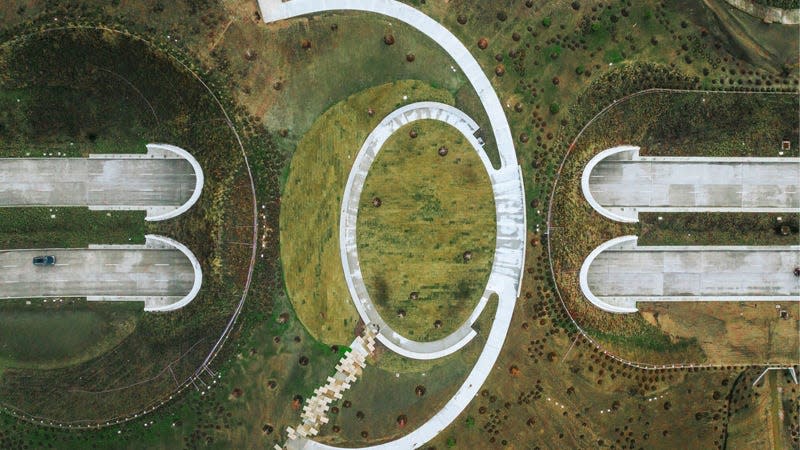
“The space, which is the largest wilderness park in Houston, has been open to the public since 1924. But in the 1940s and ’50s, as the prominence of the automobile increased and the city expanded beyond its traditional core, the park was seen as a logical place to locate a six-lane parkway, connecting the Downtown district with the emerging Uptown district to the west.
“Like many infrastructure projects of that era, this roadway, Memorial Drive, scythed a broad paved path through vibrant public space, bisecting the park into two distinct and disparate sections, one above the road and one below.”

All part of the master plan.
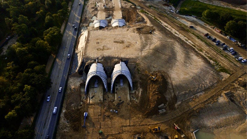
But now, 70 years later, landscape architecture firm Nelson Byrd Woltz worked with the city of Houston to reimagine the roadway and its relationship with Memorial Park.
Thomas Woltz, owner of Nelson Byrd Woltz, told Architectural Digest: “Our idea in the comprehensive plan was to create a massive earthwork that would cross the six lanes of highway. So, we designed four high performance concrete tunnels that are parabolic arches—extremely strong geometries—and then brought the soil up to cover them.”
The enormous bridges now contain footpaths and park areas for people to enjoy. But, they also offer a simpler way for wildlife to navigate the highways. Architectural Digest reports that native species will no longer need to traverse traffic, while the open space will also better prepare the landscape for extreme weather like drought, hurricanes, and flooding.
What’s more, the project has already transformed the Houston landscape, as it has become one of the highest points in the region. According to Architectural Digest:
“The result is, like the High Line in New York, a new landmark for the city that converts blighting infrastructure into a fresh and compelling public space, the Kinder Land Bridge. ‘[The size,] 38 feet, is a mountain in Houston because it’s a very flat city. So there are new views from up there, and it’s really amazing,’ Woltz says in reference to the new vertical limits of the built environment.”
Making mountains.
The opening of the new park spaces marks just a first step in a master plan for the city of Houston. And, if it proves successful, could provide a blueprint for how other states across America consider the relationship between highways and habitats.
You can read the entire article, here.
More from Jalopnik
Sign up for Jalopnik's Newsletter. For the latest news, Facebook, Twitter and Instagram.