
 Yahoo Autos
 What will potential storm do to weekend weather in Miami — and that big Dolphins game?
What will potential Hurricane Ian or Tropical Depression Nine do to our weekend, the Dolphins-Bills game Sunday at Hard Rock Stadium, and the start of the in South Florida?
Tropical-storm-force winds could start reaching the Florida Keys and the rest of South Florida Monday night, and the rest of the state by Tuesday morning, according to the National Hurricane Center’s current forecast. The National Weather Service in Miami expects South Florida could feel tropical storm conditions Monday night through Wednesday or Thursday.
But as of late Friday morning there’s still a big IF surrounding the local weather forecast — with one certainty, says weather service meteorologist Will Redman.
Be prepared
“The track right now is still pretty far out, like, four, five days. So things can change pretty quickly,” Redman said. “Basically, right now, all we can really say is to just start to get prepared now for any major impacts.”
Preparation means take in yard furniture, potted plants and other items that could become projectiles in a storm. Prep your hurricane kit. Fuel up your car, charge your power banks if you have them, withdraw cash and buy any supplies such as nonperishable food, water and medicine you may still need.
READ MORE: Florida is in the storm cone. What it means for you and what you should be doing
Sep 23: What should be in your preparedness kit? Here is a list of supplies you should have. For more information on how to prepare visit https://t.co/p7YxOUSYoL pic.twitter.com/xGS6t60syy
— NWS Miami (@NWSMiami) September 23, 2022
Florida Keys
The system was still too far out for Florida Keys officials to put protective measures in place, but they are watching the forecast closely, Monroe County spokeswoman Kristen Livengood said. And, National Weather Service Key West sent out a blunt message:
“The current forecast implies major hurricane strength is a distinct possibility!”
The weather service said tropical storm force winds could arrive as early as Monday afternoon.
“Therefore, any preparations should be complete by midday Monday. Hurricane force winds are also possible for some portions of the Florida Keys, with the most likely time frame fro the roughest weather Tuesday morning through Tuesday evening,” the NWS message said.
Forecasters said discussion on “the magnitude of specific impacts to the Florida Keys” was premature, but added people should be prepared for storm surge, “damaging and destructive winds,” flooding rainfall and the threat of tornadoes in rain bands.
11 AM EDT Sept 23: Here's the latest advisory on Tropical Depression Nine. It is too early to discuss the magnitude of specific impacts to the #FLKeys!
Please monitor future forecasts and briefings extremely closely. https://t.co/BQCTvCzxKU pic.twitter.com/XnjVP2xGi4— NWS Key West (@NWSKeyWest) September 23, 2022
Dolphins-Bills game
Kickoff at Hard Rock Stadium in Miami Gardens for the Miami Dolphins-Buffalo Bills game is at 1 p.m. Sunday.
The forecast calls for a 50% to 60% chance for a thunderstorm after 3 p.m. in the South Florida area Sunday.
“You’re just looking at some scattered light shower activity,” Redman told the Miami Herald Friday as he checked radars at the weather service. “There shouldn’t be anything really robust or anything super strong. It’s probably not going to be a lot of thunderstorm activity, either. Of course, here or there could be an isolated storm that pops up because of the time of day in the afternoon. But otherwise it should just be some some light shower activity scattered throughout the area.”
Redman said the tropical stuff that could bring stronger storms and wind and downpours would be more likely later Monday or Tuesday into Wednesday and maybe Thursday, depending on the storm’s track.
Major hurricane could hit Southwest Florida. Tropical Depression 9 track ticks west
South Florida forecast
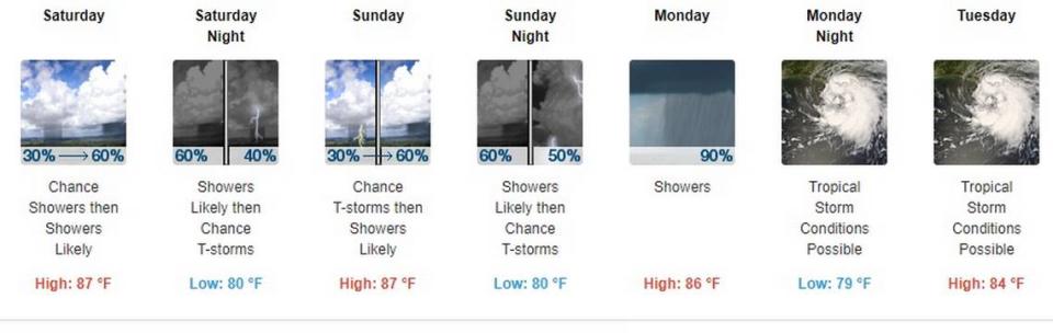
Saturday and Sunday in South Florida storm chances are in the 60% range. Monday ramps up to 90% and the weather service is advising that tropical storm conditions are possible Monday night and all day Tuesday.
If the storm makes landfall in the Fort Myers area — still an if — South Florida would be on the easterly side, generally considered “the dirty side” or a tropical system such as a hurricane. But in terms of South Florida, “it wouldn’t be as bad on this side if the track stays where it is right now,” Redman said early Friday afternoon. “It’s not going to be as as impactful on the east coast of Florida as it would the west coast” if the system follows the track.
“We’ll know more in a day or two or so,” Redman said.
Rip currents and ocean swells are also likely if the depression or hurricane tracks close to Florida or makes landfall in the state but as of Friday, given the uncertainty of the track, Redman resisted making that forecast and pinpointing a location where the coast could most feel currents and swells. Too soon.
Swells are collections of waves that are produced by storm winds that could be blowing hundreds of miles out to sea, as opposed to waves, which are generated by winds blowing locally, according to Sciencing. Swells characteristically have smoother, more regular and uniform crests and a longer period than wind waves, according to the National Weather Service.
Again, as Disney fans may recall from a tune in “The Lion King” the message for Floridians is: “Be Prepared.”
After you've put together your emergency kit, remember to maintain it so it's ready when you need it. Store your kit in a designated place where everyone in your family knows where it is kept. #BeReady pic.twitter.com/kmHV8ZbAnq
— Miami-Dade County EM (@MiamiDadeEM) September 23, 2022
