
 Yahoo Autos
 I Recreated Gran Turismo Photos in Real Life and Can’t Tell the Difference

Video games as a vector for car enthusiasm is one of the greatest things to happen to our collective passion since the first bedroom posters of the Lamborghini Countach. There have been many challengers: Forza, Test Drive, Driver, Need for Speed. But none have done it better than the best to ever do it: Gran Turismo. But that’s just it—it’s virtual. And I’ve always wanted to bridge that gap between virtual and material, to bring the game to life. I think I figured out how.
Gran Turismo 7 features a photo mode called Scapes, where a real photo of a location is turned into a semi-3D environment where you can place any of the nearly 500 cars on offer. You can settle a Bugatti Chiron into an impossibly quiet night scene in downtown Tokyo, hard park a heavily modified Nissan Silvia S15 in Normandy, or even glide around Los Angeles in a bright yellow Lexus LC 500 (hint, hint). There are 3,000 Scapes, meaning there are 3,000 places in the real world captured and immortalized by the game. Places anyone can visit—should they be able to find them.


Technically, it’s a good test of GT7’s graphics—if I could match a photo exactly, would you be able to tell which was real? But the goal was closer to spiritual than factual: I wanted to connect the dots between how we experience cars in real life and how something like GT7 captures the majesty of the automobile in a fantasy.
And there is just one car, for me at least, that always takes my breath away whenever I witness one. The choice was easy: I grabbed a Lexus LC 500 to bring two stunning, detail-crazed examples of excellence together. With this beautiful Flare Yellow example a worthy subject, I set out to find and carefully remaster the Scapes.


Finding the Fantasies
Developer Polyphony Digital doesn’t share specific location data for most Scapes, which range from obvious landmarks to random beauty shots around the world. Instead, you get a vague description, maybe a street name, but no coordinates or a pin on a map.
In the absence of a real map, the community has stepped up to crowdsource some location data, but I still had to do research to find each Scape, especially in a huge, dense urban area like Los Angeles. Some were obvious with local knowledge or a cursory Google search, others not at all. I also quickly ran into two issues: some of the best ones would result in me getting a huge ticket, and others no longer existed as they did when Polyphony captured them. Some were active street scenes where capturing the best photo would be challenging, to say the least.
Then there was the trouble of pinpointing the locations of the ones I didn’t know. It would take a certain amount of geographical knowledge, some skills with a map, and even a virtual reality headset to find some spots. Before I procured the LC 500, I scouted locations with other cars and took sample shots to note lighting, the position of the sun, and possible changes in landscape.
There are many more Scapes in Los Angeles than my small collection of eight, but I eliminated another six planned locations because of time or because they were simply too busy. It took a month to plot this out, and all I had were seven days to capture them. The weather, light, and acts of God would have to hold.
Most Los Angeles Scapes were captured at sunset, with some at night. Almost all of them were captured with the softer, more southern winter sun. Several locations would take up an entire day just because I couldn’t be in two places at once. But I strategized and picked spots across Los Angeles County that could be captured in seven days. My pilgrimage took me far and wide, from the barren but beautiful Mojave Desert to the gently beating heart of downtown Los Angeles.
[Author’s note: For maximum experience, I highly recommend listening to this short playlist I put together while reading this. Please enjoy.]
An Endless Desert
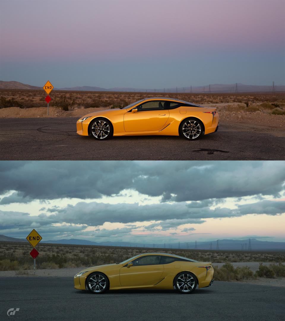
Randsburg Cutoff Road, Mojave, CA 93501
35°07'26.8"N 118°10'22.5"W
Searching for this spot took a light dose of Google Maps sleuthing with just a single clue from GT7: This is in Mojave, California. I happen to be familiar with the small town of Mojave and know that there isn’t much to look through. With the mountains in the background of the original Scape providing rough distance and location relative to the spot, I found a barren little cul-de-sac that fit the description perfectly, complete with Street View that confirmed the spot. Exactly 100 miles north of downtown Los Angeles, the first scape I ventured to with the LC 500 is a true panoramic of desert beauty.
This particular spot in the desert is not far from the Mojave Air and Space Port, a well-known airplane graveyard, hub for some private orbital flight test programs, and a one-time destination for national-level air racing. It’s at the so-called gateway to the Eastern Sierras, just a few miles away from state route 14 and US-395 that leads to the famous Lake Tahoe.
Windmills
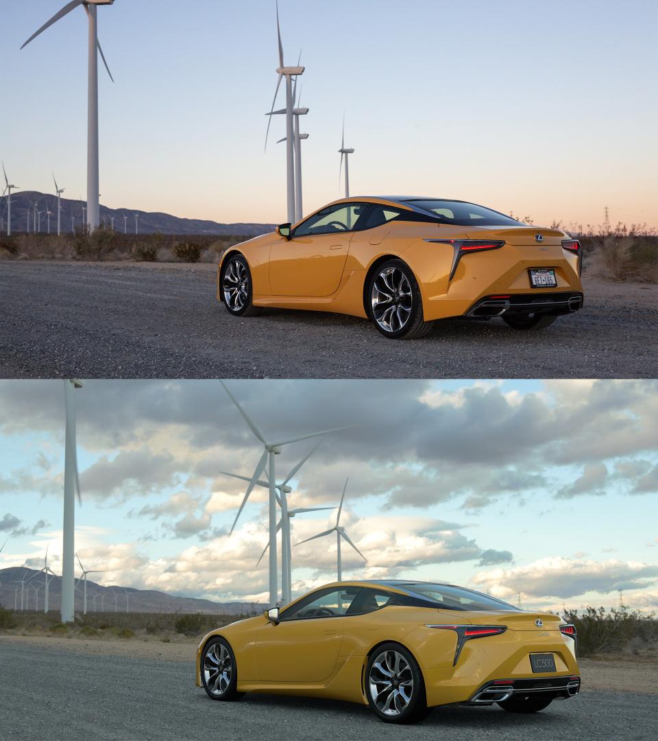
Oak Creek Road, Mojave, CA 93501
35°02'47.5"N 118°13'03.8"W
I found this spot in largely the same way, using the mountains and windmills as references. It was actually a short drive of about 10 minutes from the previous Scape, located within a massive installation of wind farms that feed power to the state of California. The area is famous for its strong winds that come from the cooler air of the Central Valley feeding into the hot Mojave through the Tehachapi pass. That, and its remoteness from major civilization makes it ideal for a wind farm.
It also makes for an incredible landscape. Windmills have a certain vibe about them, and the spot is gorgeous at golden hour. I’d even say the Scape undersells this spot; there are more beautiful angles to be found facing the other way, but it’s still a serene spot under the blades in the desert beyond LA. But it was time to journey south back toward civilization and capture the more iconic Scapes the GT7 has.
The Urban Sunset
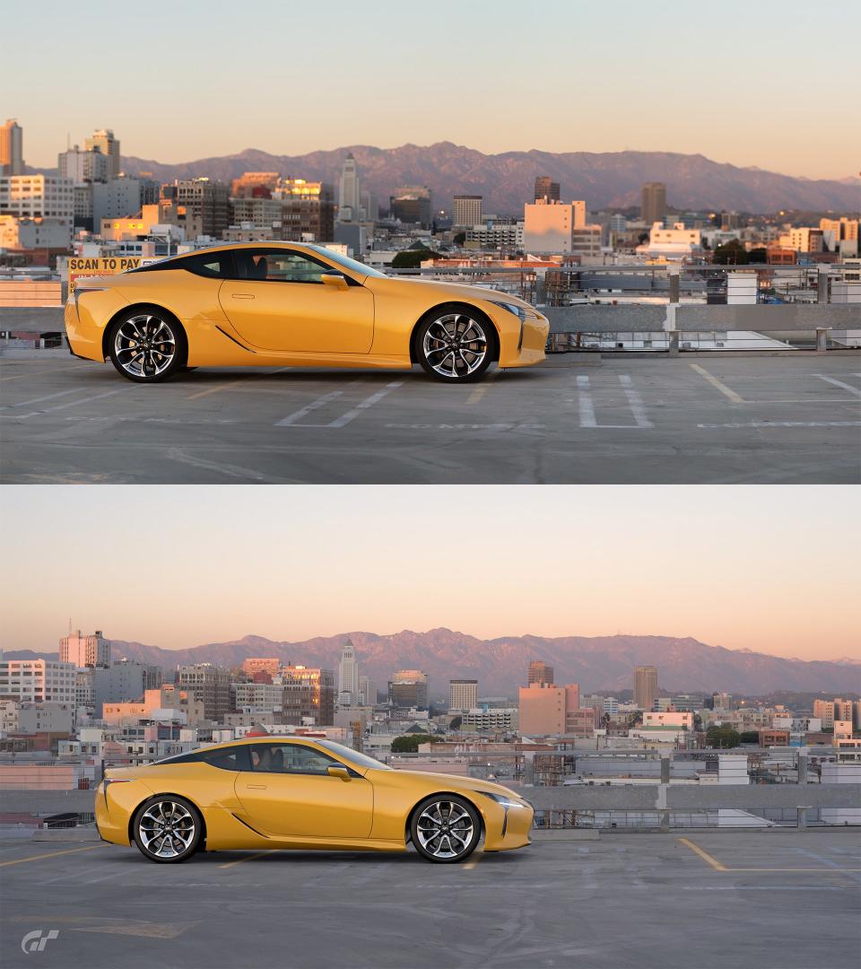
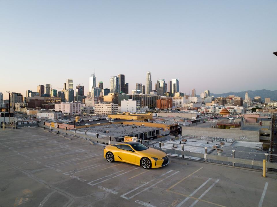
1200 Wall St, Los Angeles, CA 90015
34°02'04.9"N, 118°15'18.3"W
This was the spot that inspired everything. I originally went here in the Genesis GV60 to test the spot months before I finalized any sort of plan to do this and it was also the first moment that I figured out that this rather silly idea would work. I don’t get starstruck often, and I don’t care about celebrities. What moves me is a vision. Seeing what the team at Polyphony saw with my own eyes is beyond description. It was genuinely moving and made me giddy to see the rest. Once this shot lined up with the virtual thing down to the minutiae, the Scapes project was open for business. It doesn’t hurt that this shot is a stunner too.
Finding this shot was one of my more involved processes. The skyline and “Fashion District” designation in GT7 gave me a broad area to search, but anyone who knows the area east of Downtown LA knows it’s a mass of gray. So I picked out some landmarks, used my virtual reality headset for Google Earth VR which allowed me to place myself in situ with 3D buildings while flying around searching for the correct rooftop. After an hour of searching, using the dome just behind the LC 500 as my main reference, 1200 Wall St was the spot.
All that was left was the hope that the rooftop would be open. In LA, many parking lot rooftops are closed for various reasons, mainly to prevent people from loitering and staring at the LA skyline. The popular spots like Row DTLA, and Little Tokyo are either closed or heavily enforced. I struck gold here and found a quiet, beautiful view of Los Angeles. It’s one of my favorite spots to just exist in, beyond the fact that it’s a Scape.
A Crowded Crossing
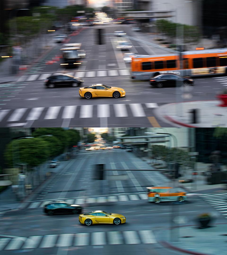
455 South Figueroa Street, Los Angeles, CA 90071
34°03'08.3"N, 118°15'25.7"W
Moving around within downtown Los Angeles, this one was more of a logistical challenge than an investigative one. With the amount of landmarks and the clear clue that it was Figueroa Street, finding it was simple. Shooting it would be a different challenge because it is a busy, one-way downtown street in the middle of rush hour. I requisitioned help from my friend Kate Gorbacheva, who is an excellent photographer and knew the particular detail I was looking in for my project. I trusted her to capture the shot while we coordinated with our phones to time traffic, lights, and when I would be crossing the frame. The bridge over Figueroa in Bunker Hill was the place we shot from, and Kate nailed the shot in a single try.
Bunker Hill is an interesting example of a place that was recently built but feels old. Where a totally built environment of skyscrapers, walkways, and wide roads now lives was once an actual hill where the Victorian homes of old Los Angeles were. Before World War I, it was the place where the ultra-rich and influential people of LA lived. In the ‘20s and ‘30s, those same people fled to Pasadena and Beverly Hills after it became LA’s densest neighborhood, along with persistent crime and overcrowding issues. All of it was razed to make way for skyscrapers in the ‘80s, which is what stands today.
A Crowded Crossing II

455 South Figueroa Street, Los Angeles, CA 90071
34°03'08.3"N, 118°15'25.7"W
This is a side shot of the same place. The shot is looking straight down south, with the iconic 777 Tower just a block down to the right. At the very end of the shot, the LA Convention Center and former Staples Center are just out of visual range.
While I had Kate, I managed to convince her and her considerable talents to also help with the night shots of LA. All I had to do was bribe her with Shabu-shabu and regroup after a short nap. For the night shots, we started at midnight and ended our session at three a.m. on a weeknight to minimize NPC traffic and police attention.
Night Moves

East 4th St, Los Angeles, CA 90033
34°02'29.7"N, 118°13'46.9"W
It’s a privilege to have Los Angeles all to yourself. But for those in the know, it isn’t a rare privilege. If New York City never sleeps, downtown LA always remembers to have a good nap from midnight to around 4 a.m., giving any enterprising young photographer the run of the place. While the historic Fourth Street Bridge is normally always busy with traffic, it is a ghost town in the dead of night, making this shot possible.
This Scape, and others located on the Fourth Street Bridge all did suffer from the evolution of LA’s east side. Just a couple of years ago, this spot in LA was a generally quiet corner of the Arts District. Now, it’s being rapidly developed with offices and high-rise residential. Most of that great cityscape in the original Scape is now blocked by a new office building, which actually rendered another excellent sunset Scape useless. Also, most of those wonderfully sodium-vapor bulbs in their original ‘40s light fixtures are either dead or turned off to save energy. The real thing is much colder, and the unidirectional march of time shows how the spot is decaying.
A Victim of Fame

253 Grand Lower, Los Angeles, CA 90012
34°03'12.5"N, 118°15'03.1"W
Lower Grand Avenue, also known as Grand Lower, is one of the most iconic car photo locations in LA. Many will have seen all kinds of photos and videos taken from underneath Grand Ave, and some might even remember it from the Tokyo chase scene in The Fast and the Furious: Tokyo Drift where the characters drift their cars through a thicket of traffic. It is so popular and well-known that it is a huge risk to take photos there. It’s practically a guarantee that law enforcement will harass you without the proper permits.
The popularity of the spot and ferocity of enforcement has markedly decreased its use, which is a shame because it was a ghost town even during its peak years. Lower Grand only serves the service levels of the buildings directly above and sees virtually zero traffic flow. There is no reason to ever drive it unless you work there or are taking photos of your car, which is why it is often closed off for private shoots.
It is an amazing place for photos, though, and versatile. The city peaks out from a gap in the ceiling above, providing light in the daytime but also an aperture to shoot from above. Which is what the next Scape does.
From Above

250 South Grand Ave, Los Angeles, CA 90012
34°03'12.5"N, 118°15'03.1"W
I think this is the cooler shot of the two, and it’s one of the most astoundingly accurate ones. I often confused the two while preparing the shots and had to remember that our shots didn’t have any parked cars on the lower level. It’s also a rare instance of the real shot being somehow more stunning than the in-game shot because of the way the LC 500 occupies the empty space so beautifully.
This is one of my favorite places in downtown Los Angeles. At night, it is almost eerily calm and quiet. It highlights what makes it such an unusual city in that downtown isn’t the core of the city. Folks enter the area to visit the various museums and attractions, then leave for their homes which are often in sprawling suburbs well beyond the mountains that tower over downtown’s skyscrapers. The core of Los Angeles at night is truly a ghost town. It’s uniquely solitary.
The End of a Pilgrimage
When I first set out to do this, I didn’t realize how significant it would be to me. Living has reached something of a screaming density since we collectively lost the ability to truly unplug. Without that, reflection is almost impossible. The moments in the car are when I get to reflect, think, and process. With every Scape I visited came new significance, and it wasn’t long before I closed on a realization.
I owe more of my love for cars to games than any single person or influence. I’m a first-generation descendant of immigrants, with nary a car person in sight during my early life. I found something in the early games I played. Need for Speed: Porsche Unleashed and Forza Motorsport were my gospel. I would finish my homework at school before I got picked up just to have more time tinkering with the cars, staring at their polygonal shapes endlessly, and relishing the fact that I could drive and hear the cars in motion. It was everything.


This journey felt like repaying that early part of myself that got into cars. The best cars are objects of passion, of hundreds of talented people pouring their skills into something that could just be transportation. They are a confluence of art, engineering, and an X factor that makes them memorable, genuinely moving examples of humanity. A great game is the same thing. The real ones are separated not by technical excellence, but by passion and execution. This is why the choice of the LC 500 was so easy; it isn’t a car beholden to statistics. It is a singularly focused object of majesty, born of passion. And it's why GT7 does what it does so well—Polyphony took their time to craft, not perfection, but artful and charismatic game design.
I found more than I expected on this journey. But most importantly, the fantasy does indeed work backward; Games can be a blueprint for breathtaking real-life experiences. Taking that LC 500 to those Scapes to pay my love back to the people who created both was something I’ll never forget. The best part is that there are 2,992 more Scapes to go.
Gallery


Want some help finding scapes? Bang my line, chris.rosales@thedrive.com
